NCW TREAD recreation app could be game changer for sustainable tourism statewide
Recreation in this state appears to be on the verge of a major transformation thanks to a unique partnership between a Methow Valley technology company, a Wenatchee-based trails nonprofit and the financial support of the Washington Tourism Alliance.
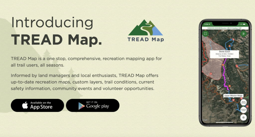
The TREAD map app, which is intended to be a comprehensive trail app for all seasons and types of trails, gives real-time feedback about trail conditions including forest fire closures to trail users like mountain bikers, hikers and motorcyclists and at the same time allows land managers like the Chelan-Douglas Land Trust and the U.S. Forest Service to manage their recreation resources.
The app is a human-centered technology solution that has already been deployed in the Wenatchee Valley and is being rolled out throughout North Central Washington this fall. If you are looking to explore new trails in our region, it’s a must-have tool that includes layers of information about how to get there, trail conditions and the like.
It is no surprise that innovators in North Central Washington are at the forefront of this project. Creative collaboration is how we have always accomplished important things, from developing hydroelectric projects to building ski areas and other civic projects.
Our public lands are under extraordinary pressure from users, a situation that has been exacerbated by the pandemic. Some of the most popular trails are being overrun, which puts our precious recreational assets at risk.
TREAD, which stands for (Trails, Recreation, Education, Advocacy, Development), is a fledgling nonprofit that was created as a result of the grass-roots Our Valley Our Future effort in 2015. Our Valley survey participants identified the need to not only develop the trails in the area as well as the need to manage them sustainably to help protect our resources.
The TREAD app started with a chance meeting a few years ago.
Marc Rothmeyer of Dharma Maps in the Methow Valley had a vision for an interactive map that could be used by land managers and users to provide continuously updated information on trails. He was looking for an organization willing to give him the information to develop a sophisticated and layered mapping program.
Meanwhile, Mat Lyons, the executive director of TREAD, was looking for the technology to promote sustainable use of trails — encouraging responsible trail use so that users might learn to appreciate and respect the lands they are using for recreation.
Lyons, a former elementary principal in the Eastmont School District, met Rothmeyer while giving a presentation to the Methow Valley Trails Association a few years ago and the TREAD app is the result.
At the heart of TREAD’s approach is a disciplined, collaborative approach bringing user groups and land managers together to develop a common vision for how best to sustainably manage local recreational assets.
Serendipitously, Lyons participated in a Washington Tourism Alliance meeting this spring and the small, local project all of a sudden became the seed of inspiration for a statewide map app developed with collaboratives like the one already in place in our valley.
David Blandford, the executive director of the WTA, said it became immediately apparent that the TREAD App could be a game changer for communities across the state. “It’s a concept, I think, that didn’t really, really exist anywhere else in the country,” Blandford marveled. These are the kinds of tools that local communities and travelers are going to want going forward, he added.
The WTA board chair at the time was Shiloh Burgess, the executive director of the Wenatchee Valley Chamber of Commerce, and a leader in the Our Valley Our Future effort. “We want (visitors) to have a great experience,” she told me. “But it’s also about developing the industries, especially those in rural parts of the state, which is where many of our outdoor assets are located,” she added.
The other aspect is building the culture of tourism “not as a nuisance but as a viable recovery approach” that enhances a community’s quality of life, she said.
The WTA is negotiating a contract with Dharma Maps to develop comprehensive trails maps across the state and also working with Wenatchee Valley TREAD to help communities build the collaborative approach to figure out how best to promote and manage their trail assets.
Once again, North Central Washington is leading the way in tackling challenging issues.


